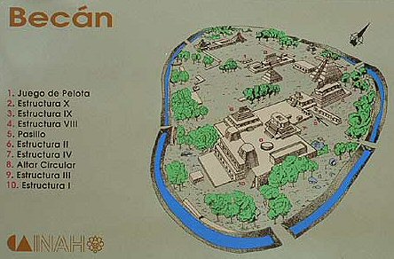
Fortified City of Becan
Location: Campeche, Mexico
Description: Regarding the defenses of Moroni, the Book of Mormon states in Alma 21:170 – “Now behold, the Lamanites could not get into their forts of security, by any other way save by the entrance, because of the highness of the bank which had been thrown up, and the depth of the ditch which had been dug round about, save it were by the entrance.” In Alma 22:2-3 – “And upon the top of these ridges of earth he caused that there should be timbers; yea, works of timbers built up to the height of a man, round about the cities. And he caused that upon those works of timbers, there should be a frame of pickets built upon the timbers, round about; and they were strong and high; and he caused towers to be erected that overlooked those works of pickets”. This description of fortified cities within the Book Mormon is very similar to what has been found at the ancient site of Becan, in Campeche, Mexico.
In “Becan: A Dramatic Validation of Book of Mormon Warfare Pattern”, Recent Book of Mormon Developments, we read, “The ditch around the site is 1890 meters (about 1.2 miles) long. … The width of the ditch varies from 12 to 27 meters with an average of 16 meters (52.5 feet). The average depth is 5.3 meters of about 17.4 feet. Webster (1976:88) states: ‘To judge from the bedrock outcrops which are still visible, the sides of the trough must have been vertical or near vertical, steep enough to keep attackers from clambering up them.’ It would not have been possible to get out of the ditch without a ladder. Webster believes there were wooden palisades on top of the bank. He states: ‘I suspect that a palisade may well have existed but that all traces of it have been obliterated. About the only remaining evidence would be a line of post holes or soil discolorations along the outer edge of the embankment, but this is precisely where the most severe erosion has taken place …’ Chronologically, the Becan fortifications could have been constructed in the Pakluum phase which is dated 150 B.C. to A.D. 250.” [26]